PRODUCT DESCRIPTIONGreater resolution with 240 x 320 display pixels
for improved readabilityInternal memory expanded to hold more
mapsHigh-sensitivity, WAAS - enabled GPS receiver with
HotFix and GLONASS support2.2-inch color displayWorldwide
basemap with shaded reliefeTrex 221X is our upgraded version of the
popular eTrex 20X, with enhanced screen resolution for a more
readable display and internal memory expanded to hold more maps. It
retains the ease-of-use, durability and affordability that eTrex is
legendary for and can also be used on ATVs, bicycles, boats, cars
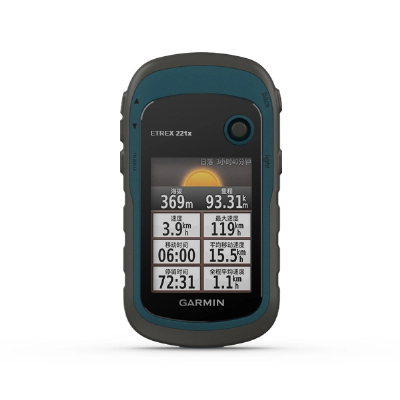
or hot air balloons.See the WayeTrex 221X has an enhanced 2.2-inch,
65K color, sunlight-readable display. Durable and water resistant,
eTrex 221X is built to withstand the elements. It has an upgraded
interface yet retains its legendary toughness to withstand dust,
dirt, humidity or water.Go AnywhereWith an array of compatible
mounts, eTrex 221X is designed as a handheld or for use on ATVs,
bicycles, in boats, cars even hot air balloons. Use the auto mount
capability and City Navigator NT maps for turn-by-turn
driving directions, or the rugged mount for your motorcycle or ATV.
Wherever you think you might take eTrex, it has the mapping and
mounts to get you there.Go GlobalThe eTrex series is the first-ever
consumer-grade receivers that can track both GPS and GLONASS
satellites simultaneously. When using GLONASS satellites, a system
developed by the Russian Federation, the time it takes for the
receiver to "lock on" to a position is (on average) approximately
20 percent faster than using GPS. And when using both GPS and
GLONASS, the receiver has the ability to lock on to 24 more
satellites than using GPS alone.Add MapsWith its microSD™ card slot
and expanded 3.7 GB of internal memory, eTrex 221X lets you
load TOPO 24K and Garmin HuntView and hit the
trail, plug in BlueChart g2 preloaded cards for a
great day on the water or City Navigator NT map data for
turn-by-turn routing on roads. eTrex 20x also
supports BirdsEye Satellite Imagery (subscription
required), that lets you download satellite images to your device
and integrate them with your maps.Keep Your FixWith its
high-sensitivity, WAAS-enabled GPS receiver and HotFix satellite
prediction, eTrex locates your position quickly and precisely and
maintains its GPS location even in heavy cover and deep
canyons.Find FuneTrex 221X supports geocaching GPX files
for downloading geocaches and details straight to your unit.
Visit Geocaching to start your geocaching adventure. By going
paperless, you're not only helping the environment but also
improving efficiency. eTrex 221X stores and displays key
information, including location, terrain, difficulty, hints and
descriptions, which means no more manually entering coordinates and
paper printouts. Simply upload the GPX file to your unit and start
hunting for caches.Plan Your Next TripTake charge of your next
adventure with BaseCamp™, software that lets you view and
organize maps, waypoints, routes, and tracks. This free
trip-planning software even allows you to create Garmin
Adventures that you can share with friends, family or fellow
explorers. BaseCamp displays topographic map data in 2-D or 3-D on
your computer screen, including contour lines and elevation
profiles. It also can transfer an unlimited amount of satellite
images to your device when paired with a BirdsEye Satellite Imagery
subscription.FEATURES Physical dimensions 5.4 x 10.3 x
3.3 cmWeight 5 oz (141.7 g) with batteries Water
ratingIPX7Battery type 2 AA batteries (not included); NiMH or
Lithium recommendedDisplay type 2.2" transflective, 65K
color TFTDisplay size 1.4" x 1.7" (3.5 x 4.4 cm); 2.2"
diag (5.6 cm)Display resolution 240 x 320 pixelsBattery
life 25 hoursMemory/history 8GBPRODUCT SHOWPACKING
& SHIPPINGPAYMENT COMPANY INFORMETIONShanghai Hexin Survey
Instrument Co., LTD has 8 years' experience in geodetic
surveying and cadastration surveying, we are a professional
and leading enterprise in the surveying industry in
MainlandChina. We specialize in the R&D and manufacturing and
sales of all kinds of surveying products, including total
station, electronic theodolite, electronic distance meter,
automatic level, laser level, reflector prism, surveying
accessory, GPS receiver, mapping software, etc.The
marketing model advocated by us is not a simple sense of "selling
products", instead, pre-sales service, services
during operation and after-sales service are
integrated in entire operating activities. It makes the customers
feel that they purchased not only a commodity, but also a
professional service.We welcome new and old
customers from all walks of life to contact us for future
business relationships and achieving mutual success!FAQQ:How
to turn off voice broadcast of receiver?A: a. Enter the WEBUI, find
the voice switch in the settings page and turn it off.b. Controller
Software→Device→Device Setting, turn off the "enable
voice", and click"ok"Q: Can the base station and rover s


Quality 2021 New Garmin Etrex221X Other Measuring Instrument Handheld GPS products, provide good price 2021 New Garmin Etrex221X Other Measuring Instrument Handheld GPS from .
Larger photo of 2021 New Garmin Etrex221X Other Measuring Instrument Handheld GPS
Related products about 2021 New Garmin Etrex221X Other Measuring Instrument Handheld GPS
-
 Waste Tyre Plastic Recycling Machinery Machine Tire Crusher Production Line Rubber Crumb Grinding Machine Equipment Tire Shredder
-
 Stretch Plastic Blowing Pet Bottle Making Blow Molding Machine Bottles Stretch Automatic Pet Bottle Blowing Machine
-
 Waste Plastic Pet Bottle, Water Bottle Flake, PP/HDPE/LDPE PE Film Jumbo Woven Bags Plastic Crusher Machine, Plastic Crushing Washing Recycling Machine
-
 Type 2 Wall-Mounted Electric Car Charging Station 7kw /11 Kwelectric Vehicle Charging Station Home Wallbox AC EV Charger Single Phase or 3three Phase
-
 G-View G12W Wholesale Auto Car LED Headlight Bulb High Power H13 H11 9005 H7 H4 Car LED Headlights LED Car Lights
-
 New Design Porcelain Round Plates Dinner Set for Wedding and Banquet
-
 China 2023 New Design Super Soft 100% Polyester Microfiber Knitted Oversized Decoration Hoodie Blanket
-
 Handmade Art Creative Materials Thickened White Paper Cup DIY Disposable Handmade Colored Paper Cup


