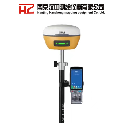
hi-target V5Product DescriptionKrey Features:1. Professional dual
camera, measurement and lofting in one step· Non-contact
measurement greatly improves the available range of GNSS, and the
operation is efficient and safe· High-performance image processing
technology based on Android, the handbook can obtain coordinates in
real time, the working distance is 2-15m, and the accuracy is
2-4cm· The handbook 360-degree AR stakeout and the host image
stakeout are seamlessly switched, immersive stakeout, the stakeout
is fast and accurate, and the accuracy is better than 2cm2. New
sensorless inertial navigation· Automatic initialization at
startup· Point-to-point measurement, efficient and convenient·
Stable and not easy to exit, reliable accuracy3. Hi-Survey
intelligent professional measurement software·Industry
high-performance CAD engine, large base map can be quickly imported
and edited, professional service engineering users·Exclusive
interactive experience, AR image measurement/real scene stakeout,
new visual measurement experience, non-contact measurement, all in
one step·Al voice control, freeing hands, easier operation4. Rich
industry data results· Enrich the types of data results to meet the
application needs of different industries· Compatible with
mainstream modeling software in the industry, point cloud and 3D
modeling in one step5. Full constellation and full frequency band,
strong signal, good data·New generation GNSS SoC chip, 1408
channels, supports B1C, B2a and B2b RTK calculation of new
frequencies of Beidou-3 satellite·Introduce multi-frequency
anti-jamming technology and multi-step adaptive filtering
technology, strong signal, good data, fast fix, high precision6.
Dual network dual standby, switch at will· Dual eSIM for the main
unit and the handbook, including 3 years of traffic, high precision
when turned on·Mobile Unicom dual network dual standby, switch at
will, one-key fixed7. Continuous test without network breakpoint·
Transceiver integrated multi-protocol built-in radio, compatible
with RTK of various brands at home and abroad· The power of the
radio is adjustable, and the typical operating distance is 7
kilometers8. Oversized iHand55 Handbook· Octa-core processor,
5.5-inch high-brightness touch screen· Built-in eSIM card with 3
years of data· Exclusive AR engine, Android10 system, smoother
operation Product Parametershi-target V5
specificationChannels1408Satelite TrackedGPS:L1C/A/ L1C/
L2P/L2C/L5BeiDou:B1l/ B2l/ B3l//B1C/B2a/B2bGLONASS:
L1/L2Galileo:E1/ E5 AltBOC/E5a/E5b/E6QZSS:L1/L2/L5/L6SBAS: L1/
/L2/L5IRNSS:L5Camera2MP&5MPSupport real scene lofting, impact
measurement, operating distance of 2-15mImage lofting
accuracyTypical accuracy: 2cmAccuracy of image
measurement2cm-4cmStatic and Fast static Gnss SurveyingHorizontal±
(2.5+0.5× 10⁻⁶d) mm (D is the distance between measured
points)Vertical± (5+0.5× 10⁻⁶d) mm (D is the distance between
measured points)Post Processing Kinematic (PPK / Stop
& Go ) GNSS SurveyingHorizontal8mm+1ppm
RMSVertical15mm+1ppm RMSInitialization timeTypically 10 min for
base while 5 min for roverInitialization reliabilitytypically
> 99.9%High-precision static GNSS
SurveyingHorizontal±(8+1×10¯6D)mm (D is the distance between
measured points)Vertical±(15+1×10¯6D)mm D is the distance
between the measured pointsCode Differential GNSS
PositionnigHorizontal±0.25m + 1 ppm RMSVertical±0.25m + 1
ppm RMSSBASPositioning accuracy0.50m Horizontal, 0.85m VerticalReal
Time Kinematic (RTK)Single BaseHorizonta:8mm+1ppm
RMSVertica:15mm+1ppm RMSNetwork RTKHorizonta:8mm+0.5ppm
RMSVertical:15mm+0.5ppm RMSInitialization time:Typically
99.9%CommunicationInternal UHF RadioFrequency:
410-470MHzChannels:116 (16 adjustable)Transmitting
power:0.5W,1W,2Wagreement:Hi-Target, Trimtalk450S, trimmarkIII,
Transeot, SATEL-3AS,South,CHC,ectWorking Range:3-5km typical,
8-10km optimalHI-TARGET External UHF Radio(HDL460A)Frequency:
403-473MHzTransmitting speed:Up to 19.2Kbps,9.6kbps
adjustableChannels:116 (16 adjustable)10W/30W adjustableWorking
Range:8~10km typical,15~20km optimalIMU(Tilt Survey)Built-in
high-precision inertial navigation, automatic attitude
compensation, no correction, anti-magnetic interference, instant
measurement at the point of arrival;Network CommunicationFull band
support for cellular mobile network(LTE, WCDMA, EDGE, GPRS, GSM)
2.4GHz WIFI, supports 802.11b/g/n. Network RTK (in CORS) range is
20-50kmPhysicalDimensions(W×H)130mm*80mmWeight≤0.97kg (includes
battery)Shock and vibrationDesigned to survive a 2m(9.84ft)
natural fall onto concreteWater/DustproofIP68Humidity100%
condensingOperation temperature -45ºC~+75ºCStorage
temperature-55ºC~+85ºCBluetooth2.1+4.0NFCNFC flash evenA serial
portRS232 serial portControl PanelPhysical buttonEnergy consumption
and working hoursElectricalPower 6V to 28V DC external power
inputPower consumption≤4.2WBuilt-in high-capacity lithium battery
7000mAh/7.4V, support USB PD3.0 super fast charging, charging time


Quality The Hot-Selling Hi-Target V5 Gnss Rtk GPS products, provide good price The Hot-Selling Hi-Target V5 Gnss Rtk GPS from .
Related products about The Hot-Selling Hi-Target V5 Gnss Rtk GPS
-
 Waste Tyre Plastic Recycling Machinery Machine Tire Crusher Production Line Rubber Crumb Grinding Machine Equipment Tire Shredder
-
 Stretch Plastic Blowing Pet Bottle Making Blow Molding Machine Bottles Stretch Automatic Pet Bottle Blowing Machine
-
 Waste Plastic Pet Bottle, Water Bottle Flake, PP/HDPE/LDPE PE Film Jumbo Woven Bags Plastic Crusher Machine, Plastic Crushing Washing Recycling Machine
-
 Type 2 Wall-Mounted Electric Car Charging Station 7kw /11 Kwelectric Vehicle Charging Station Home Wallbox AC EV Charger Single Phase or 3three Phase
-
 G-View G12W Wholesale Auto Car LED Headlight Bulb High Power H13 H11 9005 H7 H4 Car LED Headlights LED Car Lights
-
 New Design Porcelain Round Plates Dinner Set for Wedding and Banquet
-
 China 2023 New Design Super Soft 100% Polyester Microfiber Knitted Oversized Decoration Hoodie Blanket
-
 Handmade Art Creative Materials Thickened White Paper Cup DIY Disposable Handmade Colored Paper Cup


